Digital mandates, model-based approvals, and performance-driven delivery frameworks are redefining how construction projects are executed. Today’s vertical expansions, transit-integrated developments, and brownfield retrofits demand not only faster execution but also tighter spatial tolerances and multi-discipline coordination from the earliest phases. Construction teams operating in this environment are expected to deliver federated BIM models, manage data across platforms, and validate design intent in real-world site conditions all under compressed schedules and regulatory oversight.
Project typologies have grown increasingly complex. Infrastructure nodes are being stacked vertically, healthcare facilities require uninterrupted operations during phased construction, and historic structures often lack verified documentation. These conditions amplify spatial risks, misaligned cores, mislocated MEP sleeves, or prefabrication clashes. Which lead directly to rework, delays, and cost escalation. Field teams need precise spatial intelligence to make proactive decisions before materials hit the site.
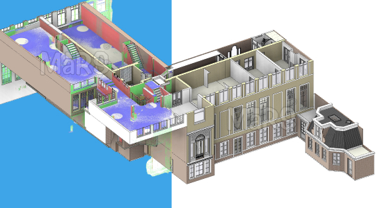
Model-based delivery alone is no longer sufficient without accurate field representation. Construction stakeholders are now adopting LiDAR Scan to BIM as a foundational step for documentation, but for validating every spatial assumption. This approach enables real-world geometry to drive design coordination, fabrication, and sequencing, reducing risk in the most spatially sensitive project scopes. For teams working within ISO 19650 frameworks or delivering digital twins, LiDAR-integrated BIM is fast becoming a baseline standard.
What Is Scan to BIM?
Scan to BIM is a construction-grade workflow where high-precision LiDAR data is captured via terrestrial or drone-based scanning. It is converted into object-based BIM models that conform to project-specific tolerances, LOD, and LOA requirements. This method is particularly critical on projects involving undocumented structures, dense MEP zones, or retrofit scopes where design assumptions carry high spatial risk. Scan to BIM links dimensional accuracy with classification logic, enabling contractors to extract verified geometry for clash coordination, layout validation, prefabrication, and sequencing. The workflow acts as a digital verification layer that aligns physical site conditions with the coordinated model, ensuring that construction teams operate on reliable spatial data from day one.
BIM and Its Role in Construction
BIM functions as a rule-based digital environment that governs not just geometry but also trade sequencing, clash logic, and construction tolerances across disciplines. On complex projects where structural embeds, MEP risers, and prefabricated systems must coexist within constrained zones. BIM enables constructible detailing at LOD 350–400, often months before site mobilization. Field engineers use model-linked layouts for sleeve punching, core alignment, and hanger placement. Subcontractors reference coordinated BIM to drive spool drawings, panel fabrication, and logistics sequencing. For general contractors, the model becomes a control surface for validating installation against design constraints, ensuring spatial feasibility before procurement or offsite assembly begins.
In high-value scopes such as healthcare, cleanrooms, or data centers, BIM is integrated into contractor CDEs to support ISO 19650 workflows and audit trails. Data-rich models feed into 4D simulations, issue tracking systems, and site verification platforms, enabling ongoing alignment between the federated design model and field execution. When linked with reality capture from LiDAR or progressive scans, BIM becomes a dynamically validated source of record. This integration allows project teams to detect field deviations in real-time, automate model-based QA/QC, and deliver models that are FM-ready at handover without post-construction rework.
Why Traditional As-Built Methods Fall Short
Conventional as-built methods fail to meet the spatial and data fidelity requirements of today’s construction delivery models, retrofit-heavy scopes or prefabrication-intensive packages. Survey teams relying on tape-based measurements or 2D markups cannot capture the geometric complexity or system interdependencies needed for LOD 400 modeling or trade coordination. These limitations directly impact BIM-based processes such as hanger layout, sleeve interference checks, and tolerance stacking across architectural, structural, and MEP systems. In projects involving modular risers, tight interstitial spaces, or embedded structural elements. The absence of precise dimensional input during early phases can lead to cascading field issues, misaligned core penetrations, and shop drawing rework.
- Inability to validate slab edge, beam pocket, and embed tolerances during preconstruction.
- Lack of geometric resolution required for MEP hanger paths, access zones, or clearance envelopes.
- Errors in sleeve and opening placement due to missing spatial context in existing drawings.
- Rework in modular systems caused by misaligned legacy dimensions or incorrect tie-in assumptions.
- Disruptions to layout workflows where robotic total station setups rely on unverified inputs.
- Model coordination failures due to undocumented ceiling voids, interstitial congestion, or structure shifts.
LiDAR Technology and Scan to BIM Workflow
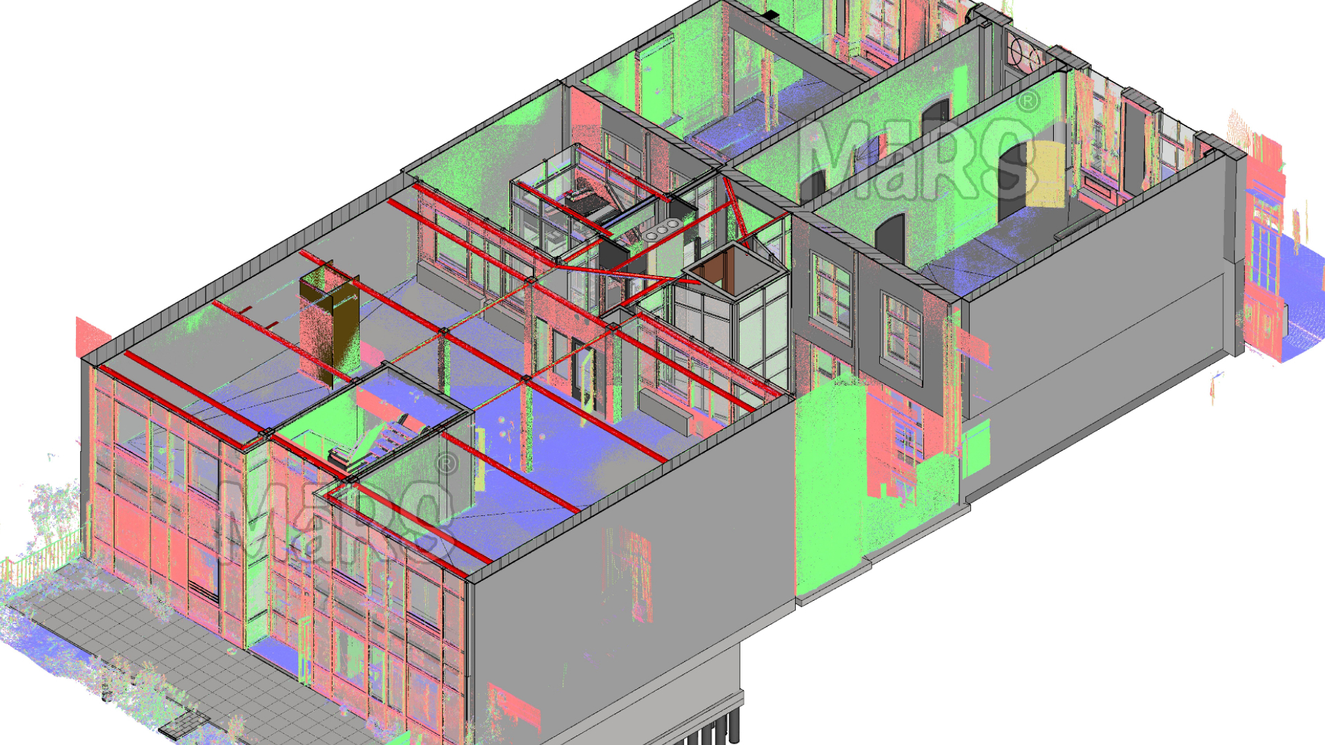
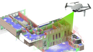
LiDAR technology is deployed on construction sites to generate high-fidelity spatial datasets, especially when conventional documentation is missing, inaccurate, or insufficient for coordination. On projects with dense vertical shafts, interstitial zones, or non-orthogonal geometries such as heritage cores or industrial retrofits. Terrestrial laser scanning delivers >2 mm accuracy, even in geometrically distorted or congested environments. Mobile and UAV-based platforms are used to scan façades, roofs, and inaccessible perimeters, ensuring full spatial coverage without disrupting site operations. LiDAR serves not just as a surveying tool, but as a means of capturing constructible constraints beam cambers, slab deformations, existing penetrations; that directly influence LOD 350+ model development and prefabrication viability.
Key Steps in the Workflow
Data Acquisition
Site teams deploy FARO or Leica scanners to capture high-density point clouds from control-based scan stations, with precision targets or GNSS inputs used to maintain spatial control across levels.
Point Cloud Registration
Multiple scans are aligned using geo-coordinates or structured targets in software like Leica Cyclone or FARO Scene, resolving drift errors and ensuring model-ready continuity across large or multi-level sites.
Point Cloud Processing
Specialists perform layer segmentation, surface reconstruction, and noise isolation, differentiating between active systems, and redundant or obstructed geometry.
Model Creation
Modelers reference the cleaned point cloud within Revit or Archicad to construct discipline-specific BIM models, tagged with metadata and classified per project standards.
Quality Control
Deviation analysis is run by comparing modeled geometry to the original point cloud using Navisworks or Verity, checking tolerance limits, geometry alignment, and LOA compliance before release.
Benefits of Scan to BIM for Complex Projects
- Millimeter-accurate field geometry eliminates spatial guesswork during layout, embed placement, and prefabrication alignment.
- Enables LOD 350–400 model development based on verified site conditions rather than legacy drawings or assumptions.
- Reduces rework on site by resolving clashes virtually using scan-validated BIM before physical installation.
- Accelerates RFI resolution by providing exact spatial context to resolve design discrepancies and trade conflicts.
- Optimizes prefabrication workflows with accurate tie-in dimensions for risers, spools, and modular assemblies.
- Supports real-time 4D simulations by integrating as-built geometry into construction sequencing models.
- Improves trade coordination through shared, reality-based BIM used across MEP, structural, and architectural packages.
- Accurate cut/fill and volume analysis for infrastructure and civil scopes using topographic LiDAR scans.
- Visual communication via clash visualizations, AR overlays, and field-verified model reviews.
- Delivers FM-ready models with geometry validated against field reality, enabling smoother COBie handover and asset tracking.
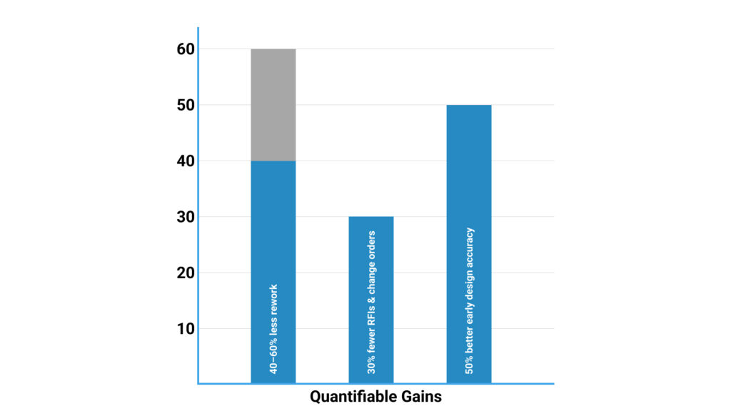
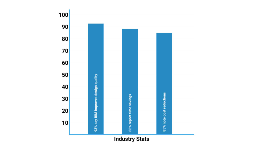
ROI and Industry Adoption
Quantifiable Gains:
Industry Stats:
Field-Level Drivers for Adoption
Contractors adopt LiDAR-based Scan to BIM workflows primarily to gain control over spatially sensitive scopes where traditional layout methods fail under field constraints. On projects involving congested MEP zones, vertical shafts, or slab penetrations, scan data enables early validation of structural openings, embed placements, and coordination clearances—well before mobilization. In renovation or adaptive reuse sites, laser scanning captures undocumented geometry with minimal disruption, allowing modelers to reconstruct accurate as-built conditions without exploratory demolition. Teams executing prefabrication rely on point cloud-derived models to define cut lengths, connector offsets, and modular tie-ins with millimeter precision. These drivers are particularly critical in hospitals, data centers, industrial plants, and retrofit towers, where dimensional tolerances are tight, access is limited, and sequencing must proceed without spatial conflicts.
Contractor-Centric Workflows Enabled
- Construction Verification: Compare in-progress work to the coordinated model using progressive scans.
- 4D Simulation Validation: Integrate as-built geometry into scheduling to detect sequence clashes.
- MEP Coordination: Support LOD 400 detailing with real-world constraints for hanger, sleeve, and riser layouts.
- Pre-pour Validation: Scan rebar, embeds, and sleeves before concrete placement for QA checks.
- Prefabrication Assurance: Confirm spatial fit for modular racks and panels prior to shop release.
- Deviation Tracking: Run automated point cloud vs. model comparisons for tolerance compliance.
- FM Model Generation: Deliver COBie-ready as-builts directly from field-verified geometry.
- As-Built Certification: Use scan-validated BIM to close out work packages with spatial sign-off.
- Issue Resolution: Identify and resolve field conflicts faster by referencing real-time scan data.
Conclusion
Scan to BIM has become a critical field-to-model workflow for contractors managing tight tolerances, prefabrication scopes, and ISO 19650 compliance. Grounding coordination in verified site conditions, it reduces layout errors, accelerates decision cycles, and supports constructible modeling from day one. Teams that deploy it early gain tighter control over spatial risk, sequencing accuracy, and model-based handover, making it a strategic asset for complex builds. As demand for scan-integrated BIM increases, it’s reshaping how contractors approach design validation, trade coordination, and digital turnover. Firms that operationalize it across preconstruction and field workflows are positioned to lead in precision-driven project delivery.


Recent Comments