Modern construction projects need more than just design coordination and basic construction drawings. They also need accurate data at every stage, reliable building performance, and smart planning across the entire building lifecycle. As AEC companies move toward performance-focused delivery, traditional BIM methods aren’t enough. They struggle to support building operations, predictive maintenance, and managing ongoing changes. To fix this, a smarter and real-time system is needed, one that combines verified as-built data with live building system information. This is where digital twin solutions, powered by laser scanning.
Digital twins go beyond static 3D models. They connect real-time data from HVAC, electrical, and other systems with laser-scanned 3D environments. This creates a detailed and dynamic model that helps monitor performance, run simulations, and improve building operations. The concept of digital twin in laser scanning uses high-resolution data from terrestrial LiDAR and mobile SLAM systems. This data forms the base for digital twins, making sure the model matches the physical building throughout design, construction, and use.
This blog explores how laser scanning and BIM work together to manage the building lifecycle. It highlights how they improve accuracy, reduce rework, and support smart decisions during handover, day-to-day operations, and long-term facility management.
Understanding Digital Twins in Construction and AEC
A digital twin in construction is a data-driven, operational layer built on top of validated BIM geometry, continuously synchronized with the physical asset it represents. Unlike conventional models that become obsolete post-construction, It remain live and operational, aggregating sensor telemetry, control system outputs, and asset metadata into a spatially coordinated environment. For contractors, owners, and facility managers operating in ISO 19650-compliant environments, the model enables status tracking, condition-based maintenance planning, and data federation across project systems.
Key Components of an AEC-Specific Digital Twin:
- Geometry Backbone: Constructed from scan-verified as-built BIM LOD 400+, supporting true dimensional accuracy.
- BMS + SCADA Integration: Ingests real-time data streams from mechanical, electrical, and life safety systems.
- IoT Telemetry Mapping: Maps live sensor feeds temperature, flow rates, vibration, and occupancy onto spatial zones.
- FM-Centric Metadata Layer: Links elements to COBie, Uniclass, and OM databases for lifecycle traceability.
- Analytics Engine: Runs condition-based simulations such as equipment failure forecasting and energy modeling.
- API-Driven Interoperability: Connects with CDEs, CMMS, CAFM, and ERP systems through RESTful APIs and IFC schemas.
- Dynamic Visualization Interfaces: Interactive twin platforms like Autodesk Tandem, iTwin, and Unity Reflect that offer 3D/4D/5D context.
By aligning high-accuracy geometry with live operational data, the digital twin serves as a single source of truth across design, build, and operate phases.It enables stakeholders to detect deviations early, optimize asset performance against benchmarks, and integrate operational feedback into future design iterations, ultimately supporting total lifecycle governance with minimal data loss between project phases.
Laser Scanning as the Foundation for Accurate Digital Twins
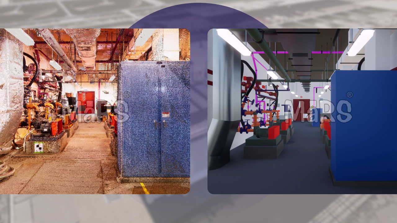
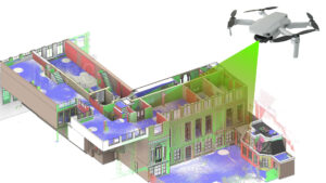
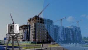
Laser scanning via terrestrial LiDAR, SLAM-based mobile mapping, and drone-mounted scanners. It serves as the primary reality capture method for generating geometrically accurate digital twins. In contrast to schematic design inputs or redline markups, laser scanning captures verified as-built conditions at the sub-centimeter level. These point-based datasets provide the spatial fidelity required to drive downstream BIM modeling, MEP coordination, construction validation, and asset integration workflows. This ground-truthed geometry enables accurate alignment of IoT sensor telemetry, facility maintenance data, and asset performance simulations.
Key Advantages of Laser Scanning:
- Captures spatial data with ±2–3 mm tolerance, suitable for LOD 350–500 model generation.
- Enables full-environment acquisition, including concealed or inaccessible service zones and tight vertical cores.
- Minimizes reliance on legacy drawings and manual measurements during renovation or brownfield modeling.
- Supports non-intrusive capture during live facility operation, minimizing downtime and safety risk.
- Ensures model-to-field alignment for QA/QC workflows, tolerance checking, and calibration.
Comparison with Other Data Capture Methods:
- Photogrammetry: Offers texture-rich visualization but fails in maintaining reliable dimensional control under low-light or featureless surfaces.
- 360° Cameras: Limited to panoramic site documentation; insufficient for producing metric data suitable for BIM workflows.
- GNSS/Total Station: Accurate for global positioning and control points but not suited for volumetric scanning of interiors.
- Drone LiDAR: Effective for exterior façades, roof surveys, and infrastructure corridors, but lacks detail for dense interior environments.
Deliverables and Workflows:
- Point Clouds: Structured datasets (e.g., *.e57, *.rcs, *.las) used for spatial indexing, surface classification, and model base creation.
- Mesh Extraction: Generation of triangulated surface models (e.g., STL, OBJ) for advanced visualization or reverse engineering.
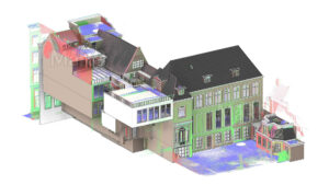
- Scan-to-BIM: Conversion of scan geometry into parametric, object-based models using Revit, ArchiCAD, or IFC pipelines.
- Accuracy Compliance: Aligned with USIBD LOA v3.0, PAS 128:2022, and project-specific tolerances (e.g., GPR survey overlays).
- Registration and Georeferencing: Multi-scan alignment using survey-grade targets or cloud-to-cloud methods for spatial accuracy across large assets.
Workflow for Creating a Digital Twin from Laser Scan Data
The creation starts with reality capture and moves through point cloud processing, BIM modeling, and integration with operational platforms.
Step 1: Capture: Use terrestrial LiDAR, SLAM-based mobile scanners, drones, or photogrammetry tools to capture high-accuracy spatial data from the site.
Step 2: Point Cloud Processing: Register and align multiple scans into a unified coordinate system. Clean the data by removing noise and segmenting it for modeling.
Step 3: Scan-to-BIM Modeling: Convert the processed point cloud into a structured BIM model (e.g., Revit or IFC). Add metadata such as material types, system specs, and equipment IDs.
Step 4: Integration into Digital Twin Platforms: Upload the BIM model into a platform. Link with IoT sensors and BMS data for real-time performance tracking.
Step 5: Model Validation: Check that geometry and asset metadata align with actual site conditions. Ensure the model is accurate, complete, and usable for lifecycle tasks.
Step 6: Outcome: A structured, data-rich model ready for use in design validation, construction monitoring, facility operations, and long-term asset management.
Digital Twin’s Role Across the Building Lifecycle
Design Development:
Scan-derived context models enable design consultants to validate spatial tolerances, structural offsets, and code-mandated clearances before schematic development. It provide verifiable terrain, floor level, and existing services geometry, improving parametric modeling accuracy and reducing design-phase RFIs across multidisciplinary teams.
Construction Phase:
During active construction, It integrate scan updates for field-versus-model validation. Twin environments are synced with CDEs to track unresolved issues, deviations from IFC models, and component install status via QR tagging or AR overlays. This supports just-in-time coordination, earned value analysis, and real-time 4D/5D sequencing.
Commissioning & Handover:
Asset-level metadata, such as airflow balancing data, transformer load profiles, and valve commissioning logs. It is captured and embedded into the twin for operational readiness. As-built MEP geometry is linked to system IDs and warranty chains, ensuring continuity between subcontractor turnover and FM integration.
Operations & Maintenance:
It connected to BMS and IoT platforms enable live monitoring of HVAC cycles, equipment health, and system performance thresholds such as delta-T variance, vibration alerts. Maintenance teams use the twin for root cause diagnostics, route optimization, and failure forecasting based on runtime data.
Renovation & Adaptive Reuse:
Historical point cloud to bim and updated geometry logs allow facility planners to trace structural shifts, piping relocations, or envelope deterioration. It acts as a master spatial database to validate design intents against previous retrofits supporting compliance-driven upgrades like fire rating recovery, egress reconfiguration, or ADA realignment.
Benefits of Integrating Digital Twin and Laser Scanning in Lifecycle Management
- High-frequency field verification using scan overlays for dimensional deviation detection.
- Reduces MEP coordination errors by aligning real-world system installs with 4D BIM simulations.
- Links sensor telemetry directly to asset geometry for performance benchmarking and anomaly detection.
- Allows construction managers to automate progress quantification using point cloud change detection.
- Supports FM teams with geotagged maintenance logs mapped to specific building elements.
- Post-construction diagnostics by integrating laser-scanned deformation analysis into the twin.
- Minimizes retrofit risk by providing a verified spatial baseline for structural tie-ins and utility rerouting.
- Capital planning accuracy through historical asset behavior visualized across time.
- Enables condition-based procurement by tracking actual equipment loads and wear patterns.
- Validates lifecycle handover deliverables by ensuring alignment between field-captured geometry and COBie-linked metadata.
Challenges and Best Practices in Digital Twin Implementation
- Managing large, multi-discipline point cloud datasets requires high-spec hardware and optimized storage workflows.
- Support alignment between federated models and field conditions demands strict scan registration protocols.
- Lack of standardized metadata tagging often causes inconsistency in asset classification and traceability.
- Integrating IoT systems with BIM platforms requires API-level customization and middleware coordination.
- Maintaining model fidelity post-handover is challenging without a digital twin governance framework.
- Difficulty in aligning real-time sensor data to geometric locations due to poor initial coordination mapping.
- Varying file formats and proprietary software create interoperability gaps between contractors and FM platforms.
- Low stakeholder adoption often stems from limited training and unclear ROI visibility.
- Absence of structured QA/QC workflows during scan-to-BIM modeling leads to downstream errors.
- Long-term success depends on establishing an asset-centric CDE and enforcing a data handoff protocol.
Leading Digital Twin Software and Tools
| Platform | Key Features | Laser Scanning Integration | Best Use Case |
| Autodesk Tandem | BIM-based twin creation, asset metadata linking, FM structuring | Supports Revit and point cloud workflows via Forge API | Handover alignment, FM onboarding, COBie integration |
| Bentley iTwin | Infrastructure-scale, iModelHub versioning | Accepts E57, RCP, and reality mesh data | Rail, transportation, utility infrastructure |
| Azure Digital Twins | Scalable IoT graph, DTDL modeling, real-time analytics | Requires middleware for geometry and scan data sync | Smart buildings, sensor-driven operational twins |
| UsBIM (ACCABiM) | IFC-native twin platform, integrated CDE tools, scan viewer | Direct support for E57, RCP, and IFC import | Public infrastructure, EU-compliant asset workflows |
| Matterport | 3D walkthroughs, asset tagging, rapid capture with Pro devices | Captures via Matterport Pro or LiDAR-enabled iOS | Interior documentation, retail fit-outs, audits |
| NavVis IVION | SLAM-based indoor mapping, floorplan alignment, scan navigation | Native integration with NavVis M6/VLX scans | Industrial plants, facility operations visibility |
| Unity Reflect | Real-time 3D/AR visualization, BIM model sync via Revit plugin | Supports mesh formats, limited native point cloud support | AR-enhanced coordination and site visualization |
Conclusion
Laser scanning and digital twins are no longer auxiliary tools—they are becoming core to asset intelligence and performance-based project delivery in the built environment. By fusing scan-verified geometry with live systems data, It allow stakeholders to track deviations in real-time, map operational KPIs directly to spatial assets, and reduce reliance on fragmented datasets during handover and FM transitions. This shift empowers contractors and owners to perform root-cause analysis, lifecycle forecasting, and field-to-model synchronization from a single source of truth. As the industry moves toward ISO 19650-driven digital asset management, the integration of LiDAR workflows into twin platforms is enabling next-generation delivery models combining geometry, data, and logic into actionable environments across planning, execution, and operations.


Recent Comments