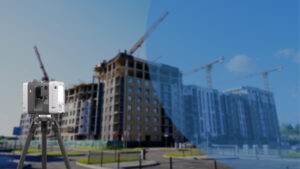
Every square foot in a real estate project carries both spatial and financial value. Planning teams now enhance this value by integrating digital site intelligence at the earliest stages. With Reality Capture to BIM services, developers access accurate, high-resolution data that reflects real-world conditions, enabling strategic decisions before designs are finalized or ground is broken. From zoning alignment to structural feasibility, digital inputs now shape the planning conversation with measurable clarity.
RC-BIM serves as a convergence point for site conditions, design logic, and development objectives. By combining advanced scanning technologies with intelligent modeling platforms, planning professionals generate digital environments that are both visually rich and technically precise. These models are built with embedded data materials, systems, tolerances, and spatial relationships. It provides teams with a shared, interactive foundation for preconstruction coordination, value engineering, and cost modeling.
The most forward-looking real estate projects are being planned with digital continuity in mind. Reality Capture workflows feed directly into BIM platforms, construction simulation tools, facility management systems, and ESG tracking software. This approach aligns acquisition, design, permitting, and execution under a unified data strategy. The result: faster approvals, optimized budgets, and high-confidence execution, all enabled by digital accuracy from day one.
Breaking Down Reality Capture to BIM
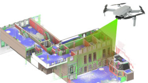
Reality Capture to BIM introduces a new level of intelligence to real estate project planning by turning spatial data into coordinated digital assets. It aligns on-site conditions with design intent through accurate, data-rich models that support feasibility studies, entitlement packages, and early-phase coordination. Each scan becomes a foundation for planning that’s grounded in measurable context. With the right tools, teams visualize geometry, map system locations, and organize real-world constraints into structured digital environments that inform design logic, compliance reviews, and cost modeling.
Technology Stack: Purpose-Aligned Tools
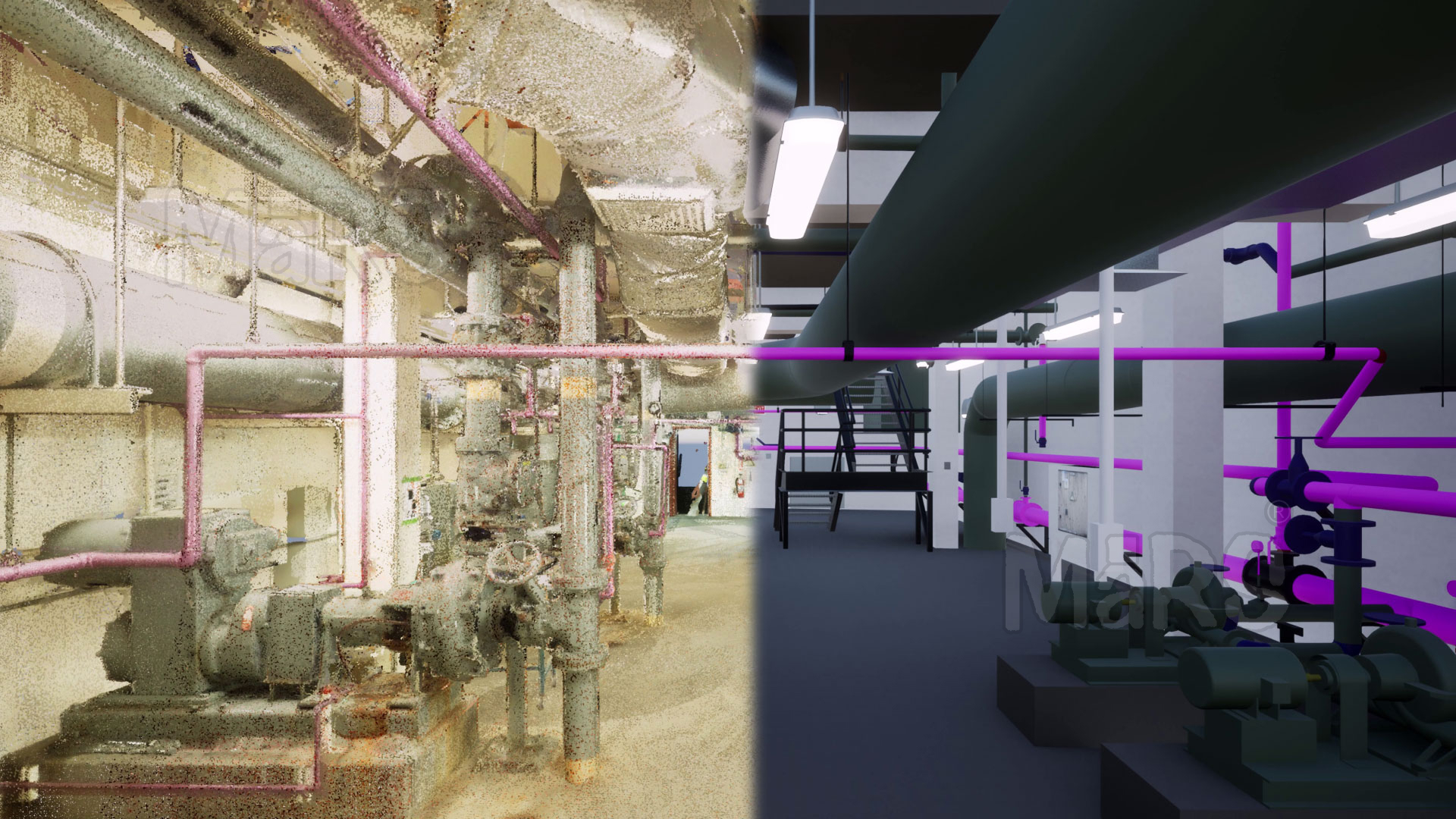
- Terrestrial Laser Scanners (LiDAR) – Deliver detailed structural geometry for interior cores, façade analysis, and base building verification
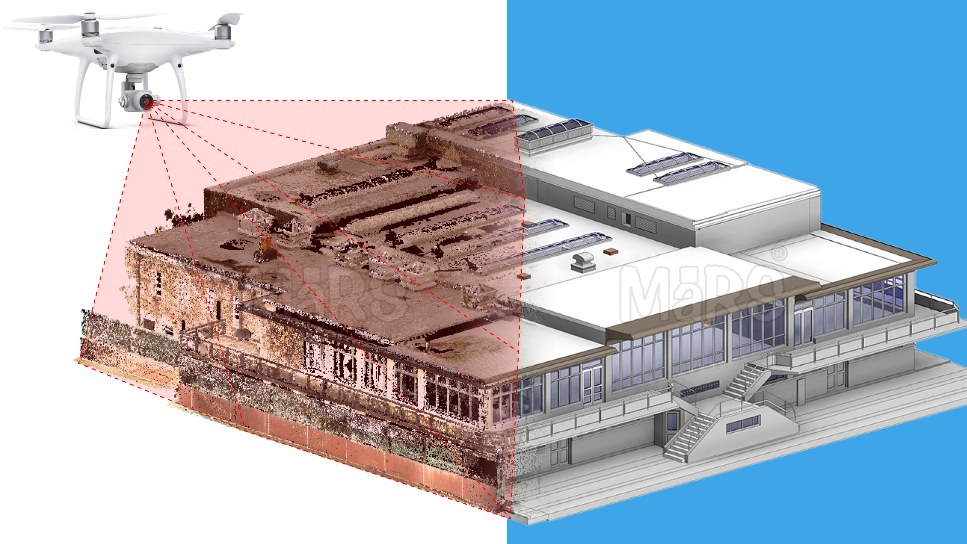
- Aerial Drone Photogrammetry– Maps large parcels and elevation profiles with georeferenced precision, ideal for early zoning analysis and topography-driven massing
- Mobile SLAM Scanning Devices – Capture dynamic spaces such as healthcare interiors or retail fit-outs while operations continue
- Structured Light Scanners – Provide high-resolution surface detail for historical preservation, FF&E placement, and architectural ornamentation
- 360° Camera Systems – Enable immersive site visualization for off-site planning, investor walkthroughs, and design presentations
- Hybrid Point Cloud Processing Software – Combines tools like NavVis IVION, FARO SCENE, and Autodesk ReCap for organized and optimized outputs
- Modeling & Coordination Platforms – Revit, ArchiCAD, and Navisworks for BIM authoring, model federation, and clash validation across disciplines
The Intelligent Planning Pipeline
Digital Site Reconnaissance
RC-BIM establishes a digital baseline for planning by capturing vertical and horizontal dimensions of a site with survey-grade precision. Teams can remotely analyze edge conditions, building adjacencies, terrain shifts, and access constraints within a georeferenced 3D environment accelerating feasibility studies while aligning early site logic with business strategy.
Geospatial Coordination for Entitlements
With reality-aligned 3D data, planners overlay zoning envelopes, utility corridors, and property lines directly onto terrain and building surfaces. This integration enables entitlement consultants to prepare regulatory documents with full spatial clarity, simplifying tasks such as FAR calculations, buildable envelope confirmation, and rights-of-way analysis.
Preconstruction Optimization
Using intelligent models derived from field-captured geometry, design teams simulate construction workflows tied to existing conditions. This includes validating structural insertions, confirming MEP routing clearances, and sequencing access for materials and equipment. The model becomes a preconstruction engine that informs decisions tied to both cost and constructability.
Handover and Lifecycle Integration
As models transition into operational assets, every component from HVAC units to custom fixtures carries digital identifiers, spatial tags, and service schedules. Facility managers inherit a federated dataset that syncs with CAFM platforms, energy models, and capital planning tools. The BIM model becomes a dynamic reference point across the entire lifecycle of the property.
Where RC-BIM Changes the Game for Real Estate Teams
Transaction-Ready Data
RC-BIM equips development teams with spatial documentation that supports acquisition modeling, FAR analysis, and yield projections delivered in formats ready for underwriting and investment reviews.
Zoning-Informed Massing
Using RC-BIM, teams simulate buildable volume directly against real site geometry. This enables early validation of massing potential, envelope setbacks, and daylight access with measurable precision.
Design Logic Anchored to Reality
Architects and consultants receive clean, geolocated base models that reflect actual conditions. Design assumptions align with what exists reducing downstream model adjustments and accelerating approvals.
Parallel Strategy for Rollouts
Developers managing high-velocity programs such as QSR, industrial, or co-living; gain the ability to scan, model, and coordinate dozens of sites simultaneously with location-specific intelligence built in.
High-Value Applications: Not Just Buildings
Transit-Oriented Development Modeling
Capture adjacent infrastructure tracks, platforms, utilities, and elevation changes; to align mixed-use design with rail, metro, or bus terminal interfaces.
Air Rights & Vertical Expansion Feasibility
Use precision scans of rooftop mechanicals and parapets to evaluate structural viability and spatial allowances for upward additions in dense urban markets.
Multi-Phase Campus Renovation Planning
Generate federated models of academic, R&D, or medical campuses to support phased construction while maintaining operations and minimizing logistical overlap.
Retail-to-Last-Mile Logistics Conversions
Scan decommissioned big-box retail footprints to model racking systems, loading zones, and clearance profiles for e-commerce fulfillment retrofits.
TDR-Backed Massing Simulation
Use accurate building and lot geometry to visualize Transfer of Development Rights potential and model vertical stacking within zoning constraints.
Facade-Integrated Energy Modeling
Scan heritage or curtain wall systems to inform glazing replacement, shading studies, and solar exposure simulations all within BIM-ready context.
Long-Term Leasing & Subdivision Strategy
Use hyper-accurate digital twins to define leasable zones, simulate interior demising walls, and test-fit development for brokers and asset managers.
Case Example: Digitizing Wegmans Retail Store for Space Optimization
Scan to BIM Solutions successfully delivered a full-scope Scan to BIM project for a major Wegmans retail store in Washington. The building encompassed diverse zones—including customer-facing areas, product aisles, cold storage, service corridors, and back-of-house loading docks making digital coordination critical for future renovations.
RC-BIM Strategy
To capture the real-time condition of the store, our team deployed high-accuracy laser scanners, generating a comprehensive point cloud dataset. Using Autodesk ReCap, the raw scans were cleaned and registered, then imported into Revit for detailed modeling. Every architectural and structural element walls, columns, ceilings, shelves, and HVAC layouts was modeled to LOD 300 precision.
Outcomes Delivered
- Produced a highly accurate Revit model reflecting the store’s actual conditions
- Enabled the client to plan interior upgrades and layout reconfigurations with zero operational disruption
- Supported facilities management through a centralized digital model
- Detected coordination issues using Navisworks for clash-free system planning
- Provided a future-ready BIM asset for ongoing maintenance, expansion, and compliance
Technical & Operational Considerations
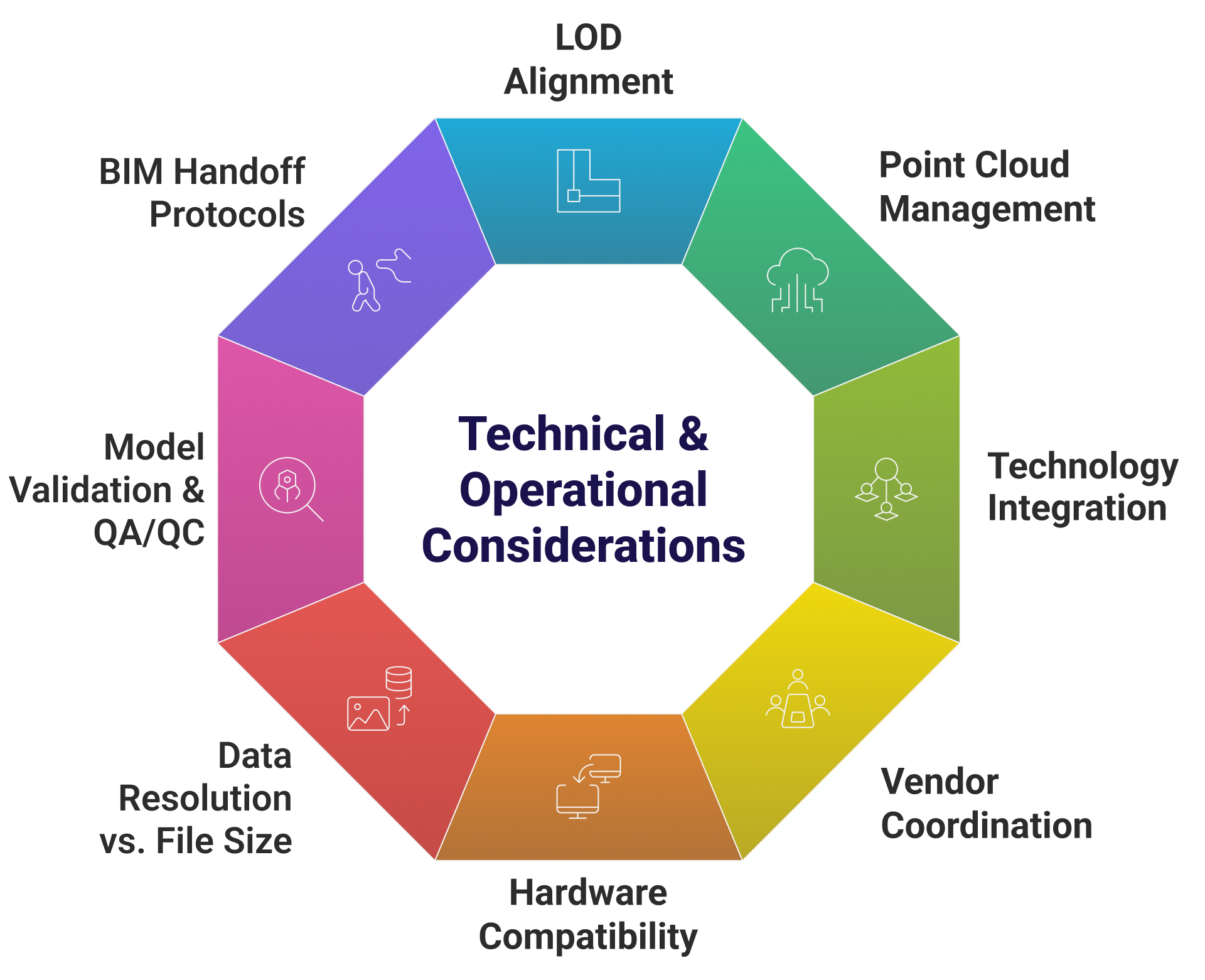
Point Cloud File Management
Use structured file formats such as .E57, .RCP, and .RCS, optimized for efficient cloud-based storage and easy integration into BIM authoring platforms.
LOD Alignment
Define the appropriate Level of Development like LOD 200 for planning, LOD 300 for design coordination based on the project stage, client use case, and asset lifecycle goals.
Technology Integration
Ensure data flow between tools like Autodesk ReCap, Revit, Navisworks, BIM 360, and facility management platforms such as Archibus or Planon.
Vendor Coordination
Clear communication protocols between drone operators, laser scanning vendors, and modeling teams to align on site access, data format standards, and scope expectations.
Hardware Compatibility
Use devices with high-precision specifications matched to indoor or large-scale exterior environments.
Data Resolution vs. File Size
Balance scanning density with manageable file sizes in multi-floor or long-span buildings by tailoring LiDAR settings or photogrammetry resolution to project goals.
Model Validation & QA/QC
Implement visual cross-checks, tolerance thresholds, and clash detection routines to ensure the model accurately represents captured site conditions.
BIM Handoff Protocols
Deliver models in client-specified formats like .RVT, .IFC, and coordinated 2D drawings while including metadata for space types, system zones, and asset tagging.
Regulatory Compliance, Sustainability, and Safety
For real estate portfolios involving occupied stores, phased upgrades, or historical conversions, Reality Capture to BIM delivers a reliable foundation for pre-approvals, tenant coordination, and facility compliance. At Scan to BIM Solutions, we integrate site-specific zoning data, occupancy classifications, and equipment access zones directly into the BIM environment, allowing clients to validate ADA pathways, egress routes, and utility code alignment before making physical changes. BIM outputs support energy performance benchmarking and space utilization analysis, which are increasingly required in sustainability-driven lease and retrofit programs. This proactive modeling approach also helps safety teams assess load-bearing clearances, rooftop access points, and emergency circulation paths in large-scale commercial assets.
Conclusion
Reality Capture to BIM transforms buildings into precise, data-rich models that support confident decision-making from the earliest planning stages through ongoing facility management. This process allows real estate and AEC teams to work from verified site conditions, accelerating timelines for space planning, compliance reviews, and phased upgrades. Whether it’s retail modernization, large-scale asset reorganization, or new development, RC-BIM delivers consistent value across disciplines and project types.


Recent Comments