Photogrammetry
What is Photogrammetry?
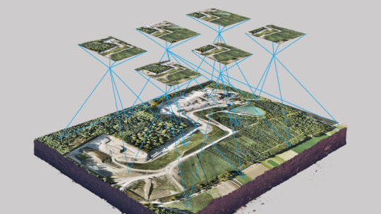
Photogrammetry is obtaining accurate measurements and creating 3D models from photographs. It involves capturing images from various angles using drones, cameras, or other imaging devices, and processing these images using specialized software. The result is highly detailed, georeferenced 3D models, orthophotos, and point clouds that provide valuable spatial data.
How Our Photogrammetry Service Works?
- Initial Consultation: We begin by understanding your project needs, goals, and the specific data you require. Our team will help determine the best approach and equipment for your project.
- Image Capture: Depending on your requirements, we will capture high-quality images using drones, ground-based cameras, or other photogrammetry equipment. Our experienced operators ensure that the images are collected efficiently and accurately.
- Data Processing: After image capture, our team processes the photos using industry-leading photogrammetry software. This includes aligning images, generating point clouds, and creating 3D models or orthophotos. The data is then georeferenced to ensure the highest accuracy.
- Deliverables: The final output can be delivered in various formats, including 3D models, orthophotos, contour maps, point clouds, and more. We tailor the deliverables to meet the specific needs of your project.
How Photogrammetry Can Benefit Your Projects?
Whether you’re in construction, surveying, agriculture, or any other industry requiring detailed spatial data, photogrammetry provides an innovative and cost-effective solution. Below are the key ways photogrammetry can enhance your project:
- Efficient Data Collection: Drones and cameras can cover vast areas quickly, reducing the time and resources needed for traditional surveying methods.
- High Precision: Modern photogrammetry technology ensures that the models and maps produced are accurate and reliable, essential for high-stakes projects.
- Cost-Effective: By using standard cameras or drones, photogrammetry eliminates the need for expensive equipment like traditional total stations or laser scanners.
- Versatility: It can be applied to a wide variety of industries, from construction to agriculture, providing detailed and actionable data without the need for physical contact with the environment.
Benefits of Photogrammetry
- By reducing the need for expensive equipment like laser scanners, photogrammetry provides a more affordable solution for 3D modeling and mapping.
- Modern photogrammetry software can create highly precise models and measurements that are often on par with traditional methods like laser scanning.
- Drones and cameras can quickly capture large areas of land or complex structures, speeding up data collection compared to manual surveying.
- Since photogrammetry relies on photographs, it can be used in sensitive areas like archaeological sites or hazardous environments without disturbing the surroundings.
Applications of Our Photogrammetry Services
Construction & Infrastructure
Photogrammetry allows for the creation of detailed site models, as-built documentation, and volume calculations. It also aids in progress monitoring, helping to ensure your project stays on schedule and within budget.
Land Surveying & Mapping
We provide precise topographic surveys, terrain models, and 3D mapping. This is especially useful for large-scale projects, enabling accurate planning and analysis.
Heritage Preservation
Document and preserve cultural heritage sites or historical artifacts without causing any disruption, ensuring that detailed records are available for future restoration or study.
Environmental Monitoring
Use photogrammetry to study environmental changes like erosion, deforestation, or flood impacts. This non-invasive method provides detailed insights for researchers and environmentalists.
Why Choose Our Photogrammetry Services?
- Experienced Team: Our team consists of highly skilled professionals who have years of experience in capturing and processing photogrammetric data.
- State-of-the-Art Equipment: We use the latest drone technology, cameras, and software to provide you with the most accurate and high-quality results.
- Custom Solutions: We understand that every project is unique. Our photogrammetry services are tailored to your specific needs, ensuring you receive the most relevant and useful data.
- Fast Turnaround: Our efficient processes and technology enable us to deliver high-quality results promptly, helping you keep your project on track.
- Affordable: Photogrammetry provides a more cost-effective solution compared to traditional surveying and mapping methods.
Frequently Asked Questions (FAQs)
Photogrammetry is creating accurate 3D models, maps, and measurements from photographs. It uses overlapping images taken from different angles to generate detailed spatial data.
Photogrammetry is widely used in construction, surveying, agriculture, mining, environmental monitoring, and heritage preservation, among others.
Photogrammetry involves capturing high-quality images from drones, cameras, or other devices. These images are processed using specialized software to create 3D models, orthophotos, and point clouds.
Deliverables include 3D models, topographic maps, orthophotos, point clouds, contour maps, and volume calculations, all tailored to your project needs.
Yes, photogrammetry provides highly accurate results, often comparable to traditional surveying methods, and can be georeferenced to ensure precision.
The timeline varies based on the project size and complexity, but we strive to deliver fast and efficient results, usually within a few days to a few weeks.
Yes, photogrammetry is a more affordable solution compared to traditional surveying and mapping methods, especially for large or complex projects.
Yes, drones and cameras can capture images in hard-to-reach or hazardous locations, making photogrammetry ideal for remote or difficult-to-access areas.
Simply contact us for an initial consultation. We'll discuss your project needs and determine the best approach for your specific requirements.